Shifting Sands: Tracking the Changing Shape of Our Shore [Podcast]
Show Notes
From major storms to daily tides, the sandy shores of New Hampshire are constantly moving — gaining sand in some places and losing it in others. But how do scientists and volunteers actually track those changes over time?
In this episode of Time and Tide, we dig into the world of beach profiling — a simple yet powerful method that measures the contour of the shoreline month after month to reveal patterns of erosion and accretion along our coast. By taking regular measurements of beach elevation and slope, the NH Volunteer Beach Profile Monitoring Program contributes to long-term coastal monitoring efforts that inform local decision-making, coastal resilience planning, and scientific research.
Learn how citizen scientists — also referred to as participatory scientists — use two measuring poles to collect this important data, while researchers interpret its meaning for your favorite New Hampshire beaches.
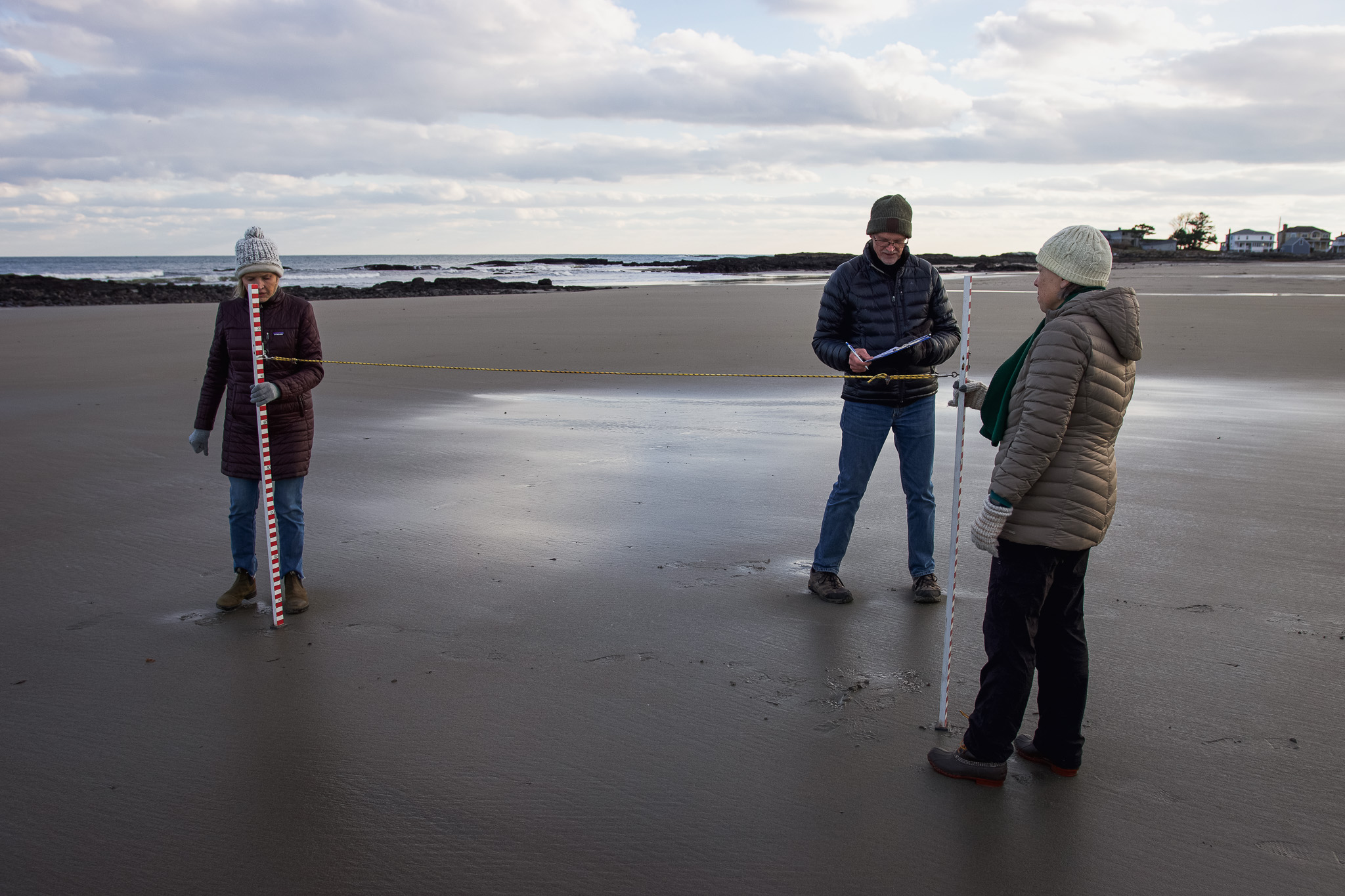
What better way to explain beach profiling, than to take you for a walk along the beach in Seabrook, NH, where a small group of researchers and volunteer citizen scientists meet on a windy winter day to measure the beach.
Full episode transcript is available below.
Guest Speakers

Alyson Eberhardt, Ph.D.
Coastal Ecosystems Extension Specialist, New Hampshire Sea Grant

Larry Ward, Ph.D.
Research Associate Professor, UNH Center for Coastal and Ocean Mapping

Rachel Morrison
Research Assistant, UNH Center for Coastal and Ocean Mapping

Wells Costello
Citizen Science Program Manager, New Hampshire Sea Grant

Cathy
Coastal Research Volunteer, New Hampshire Sea Grant
Deborah
Coastal Research Volunteer, New Hampshire Sea Grant
Meet Your Host
Brian Yurasits,
Host & Producer
Science Communication Specialist,
New Hampshire Sea Grant
More Episodes?
We've got you covered! Time and Tide is available wherever you get your podcasts.
Episode Transcript
Wells Costello: We have over 35 full-time volunteers. We monitor 15 sites ranging from Seabrook Beach right here as our southernmost site, all the way up to Wallis Sands State Park, roughly 18 miles of coastline. Those 15 sites, we have typically two to three sites per beach, and yeah, we head out once a month at the lowest of low tides and sometimes pre and post storms.
Brian Yurasits: So picture this, you're standing on a beach in New Hampshire. Maybe it's Hampton, Jenness or North Beach. The tide is out and the sand stretches wide in front of you. The waves are quiet, just barely breaking. It looks peaceful like it always does. But here's the thing, this beach is changing. [00:01:00] Every high tide, every storm, every gust of wind, it's all shaping the shoreline, shifting the sand, redrawing the map in ways that most of us don't even notice. But some people do. Every month rain or shine, a group of volunteers walks out onto the beach with measuring poles in hand. They mark the sand, take their readings, record the numbers. This is beach profiling. It's simple, it's precise, and over time it tells a bigger story about the erosion and accretion of sand along our coastline and why it matters. Today on Time and Tide, we're talking about this quiet but critical work.
How everyday people from retirees to students are tracking the slow drift of New Hampshire's sandy beaches. We'll talk about how each of New Hampshire's beaches are changing. Why citizen science also referred to as participatory science can be such a powerful tool to collect data and we'll meet the volunteers, the people who show up month after month to measure the sand, not because they [00:02:00] must, but because they care. I'm your host Brian Yurasits, and this is Time and Tide.
Today you'll tag along with the beach profiling and team as we walk along Seabrook Beach in New Hampshire. We all park along the street, throw on an extra layer and gloves for warmth and head out onto the beach path along the dunes. We stop at a high point in the seemingly vast and healthy dune habitat and listen to Alyson Eberhardt and Larry Ward as they explain how this program first began.
Alyson is the Coastal Ecosystems Extension Specialist here at New Hampshire Sea Grant, and Larry is a Research Associate Professor at the University of New Hampshire's Center for Coastal and Ocean Mapping. Fair warning, there's a cold wind blowing, which you'll hear pretty clearly.[00:03:00]
Alyson Eberhardt: So about maybe 10 or 11 years ago, Chris Williams from the Coastal Program approached Larry and me with a concern about a lack of data to inform beach management decision making, and asked if that was something we could do. Larry and I got together and said, yeah, absolutely. And that was the beginning of New Hampshire Volunteer Beach Profile and Monitoring program.
So Larry had had some graduate students collecting similar data and we knew that a graduate student approach to getting the data wouldn't quite work, 'cause we wanted to collect data at more sites more often. So that's why we went with a participatory approach or citizen science. We had a great model from Southern Maine and so adapted it and developed the program.
The goals are to collect a long-term data set on beach dynamics, so looking at erosion and accretion and storm response and recovery.
Larry Ward: We started the Volunteer Beach Profile Monitoring Program in 2017. We wrote the proposal and we started the field [00:04:00] work in January, 2017 with three stations, one at Wallis Sands, one at Hampton, and one at Jenness Beach.
The next year, we increased it to 12. From that time, it's gone up to 15 as we recognize sites where we thought we needed more information. My role in the overall project is how you do the profiling, how the data's processed, how it's archived, and how it's interpreted.
Brian Yurasits: Larry then dives deeper into why each of these 15 Sandy Beach sites were chosen by the team.
Larry Ward: In determining what beaches we'd study, several things gotta be taken into consideration. First of all, the importance of the beach. Size, use, is it pristine, is it heavily developed, what's the urban location around it, so on. So you wanna look at a variety of settings. So, we chose the beaches and the locations to have stations on the beaches based on accessibility. On a day like today, doesn't matter, you can walk half a mile and be happy. But in January with icy conditions, you don't want to go very far. We have to have [00:05:00] landowners who give permission to cross their property or park in their yard. So you have to take into consideration the beach that you wanna study, the need for the studying that beach and then access all year round. All the stations have to be permanently marked with some sort of a post or some feature that we then shoot in very accurately to position, so all our profiles are tied into datums so they can be compared to each other.
Brian Yurasits: What data are volunteers able to collect by using two measuring poles in a string? You might be wondering. Larry and Alyson have an answer for that too, along with who uses that information.
Larry Ward: The purpose of this study using very rudimentary methods, hitting a lot of stations for a long period of time, our goal is to understand how the New Hampshire beaches change. Look at their parameters such as mean elevations, how quickly they respond to storms, how they've changed over time, the elevation of the morphology, and provide that information to the New Hampshire Coastal Program, Parks and [00:06:00] Recreation or whoever might want to use it. We have talked in the past with the state, occasionally legislatures, senators from the coastal area.
We're working hard now to integrate our results and share it with people responsible for managing the coast.
Alyson Eberhardt: Some of our project partners are the New Hampshire Geological Survey who helps support our data portal, and then the folks that are using our data are beach managers and landowners. So, we're in contact with New Hampshire State Parks quite a bit. We're working with municipalities. We've also recently started conversations with the Army Corps of Engineers about using our data to inform beneficial reuse decisions around the state of dredge material.
Brian Yurasits: Why choose to work with participatory scientists, though? Why not just do this work themselves?
How do they ensure that this data collected by volunteers is reliable, especially when it's being used to make really big decisions?
Alyson Eberhardt: New Hampshire Sea Grant is involved in two primary capacities. One is, we do a lot of work in the participatory sciences, and [00:07:00] so partnering with community members in the research process. We also are focused on moving data to action, so connecting data to the end users.
I see my role as the intersection of science and people, I think many of us at Sea Grant do. And so this is an opportunity for us to work in a coastal ecosystem, which is my job, and not only create more capacity to collect data, but also learn from the people that love these places, that live in these places, that recreate, spend time in these places.
Larry Ward: I was a little bit hesitant at first, to be honest. I've seen other volunteer programs that were not run as tightly as perhaps they should have been, and people with good hearts and good efforts going out, but not really being well-trained. And from this perspective, let's be interactive to creating a team where we have Wells and we have Alyson and myself and Rachel, and we take turns going into the field and not just once, but all the [00:08:00] time.
So the idea is to give them constant feedback and then we really spend a lot of time examining the data that's collected. I feel like we've been very successful. If I did this with graduate students or technicians it'd be 10 times, 20 times the cost. My hesitancy to use a lot of untrained people, even though they have great interest in intelligent and great backgrounds in different areas, totally wrong.
Right now, crowdsourcing has become a huge and needed part of science. And that's our job as a scientist and the outreach, to find the people, design the studies and use it properly.
Brian Yurasits: So after all of these years of beach profiling. What are the results that have been discovered?
Larry Ward: One thing really surprised me. That from our beach profiles, Seabrook, this area right here has a much higher elevation, not just in the dunes, but on the beach compared to Jenness Beach or North Beach, which means when we have a storm surge, it's not gonna inundate nearly as far. You get a large high tide here and it's still way down on the beach. [00:09:00] Hampton Beach is the other high, really high beach. They're in very good condition right now, whereas North Beach and Jenness Beach are not, they're sitting very low, so they get the infrastructure behind the beach gets impacted during storms.
Wallis Sands are somewhere in between. So, what we're trying to do is get a handle on that a little bit, and one of the purposes, if we're gonna manage the beach, if we're gonna try beach nourishment, then where would you wanna put it? Where would be the place that needs it the most? Seabrook, no. Hampton, no. But North Beach, Jenness, yeah. That's kind of the whole crux. It's expensive to put sand on a beach and this problem's gonna get worse. It's not gonna get better. Climate is changing rapidly, overall warming, but some places are getting stormier, some are getting cooler, warmer, but there's major shifts.
You can see it on every aspect of the globe. And with that, you're gonna see an acceleration of sea level rise. So, the beaches are going to have more problems with the rise in the water levels, slow rise millimeters per year, centimeters. But still, that's enough to have an impact. But my view is be as pragmatic as you can [00:10:00] now.
Use resources like beach nourishment and so on, and properly design structures and soft and living shorelines. Buy as much time as you can, but ultimately we're gonna have to let it retreat, and that's just a normal progression, retreat with sea level rise. But that's my personal perspective. It's a very dynamic area and it's not gonna settle down and just start being stable and sitting quiet.
Brian Yurasits: Now that we have the background from Alyson and Larry, we continue our stroll onto the beach itself. Where Wells Costello, Citizen Science Program Manager at New Hampshire Sea Grant, gets into the finer details of beach profiling. What's with the two poles and how do volunteers actually collect this data so reliably that it's changed Larry's perspective on working with volunteers to conduct science.
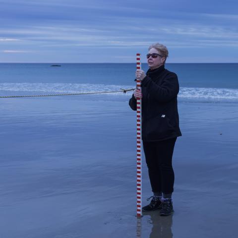
Wells Costello: We're here. Beach profiling is a simple way of measuring the beach. We use the Emery profiling method. We're using that to monitor the accretion, the gaining of sand, or erosion of sand on New Hampshire beaches. And it's all tied into a fixed point, a known [00:11:00] point. All of our sites have a known data point, a way point, and it's all derived from that so we can monitor change over time. Well, it starts with two sticks and a string, kind of getting a cross section of the beach with, you know, a group of three people. Each one has their own distinct way of making sure that the profile is going well. I'd just say it would probably be three meter increments, bumping along the beach as you're kind of mimicking the slopes and the little innuendos of the sand. You know, something unique in my role in New Hampshire Sea Grant and really unique to Sea Grant as a whole, like the whole network is that, yeah, my job entails managing participatory science projects. This is one of many, definitely my favorite.
And so my role is really kind of the middle person between the researcher and the community members or volunteers. Training them on the protocols and the methods, answering their questions, their concerns, and kind of being that [00:12:00] sounding board for them in between Larry, the researcher. And vice versa, for Alyson, Rachel and Larry, who I work with, they have questions or concerns I take that stuff and I relay it to the volunteers. And I think it goes to show you how important volunteers are for New Hampshire. I feel like when I first started with citizen science, I really cared about the data, the science of itself, but I realized that so much of our work is working with people and building those relationships.
I think data alone can't really convince people sometimes of saying, hey, let's make a change, or hey, let's make a management decision. I feel like it's more than that. When they've built a relationship with you, they have the trust in you or they know you, they're more likely to look at that data and say, hey, let's use this, or, hey, you know I trust this person. But if you walk into the room, they don't know you or they don't like your vibe, they're not gonna even consider your data, even if it is the same data. I mean, that's why kind of extension was created because so much [00:13:00] research, you don't want it to be siloed. You want it to be out to the greater community as almost like a public service.
You know, both on a professional level and a personal level, I don't know how many times people have invited me to be like, hey, we're gonna get pancakes before beach profiling, you wanna come? And like, it's a real social element of science and I think just makes a stronger community. And yeah, especially during the pandemic, I don't know how many people reached out when we had to close down the beaches and it wasn't like, oh, you know, I really want to collect data, which was an important part.
It was like, hey, I miss coming out with my beach profiling family and so it's like really tight knit, it's really close and I love seeing the different dynamics of all the profilers, which I get to see 'cause I visit all of them in the field.
Brian Yurasits: Rachel Morrison, Research Assistant with the University of New Hampshire's Center for Coastal and Ocean Mapping, works closely with Larry and the team and explains what happens next once the volunteers write down their data.
Rachel Morrison: I've been involved with the project since 2018 and I do most of the data processing. All of the [00:14:00] data that the volunteers collect. I try to come out and meet with the volunteers. Wells and I sometimes train people and we just kind of check in with the volunteers and make sure that they know what we need from them and how best to take pictures and enter their data.
The volunteers upload the data to this shared Google Drive folder, and then I download that data and we archive it. From their data we can plot it like relative to this station marker and calculate volume and elevation over time. And it's just really interesting to see how you can take all this data that they collect every month on all 15 stations and then we get a single number that represents each month and each beach and we can compare it between months and between stations.
And so it's just kind of neat to see how that data all ties in together and how it's related. Beaches like where we are now, where their dunes are a lot more protected I think 'cause they have a little bit more steady sand [00:15:00] supply or the dunes can hold onto the sand, but the beaches that have like the seawalls, they're already kind of low, like sitting at a low elevation, and so when the storms hit the seawalls and it just erodes the sand much more easily. So the northern and central beaches are a little bit more vulnerable. Everyone loves coming to the beaches. It's obviously like, I know we have such a tiny coastline, but it's a very special part of New Hampshire and there are a lot of homes and businesses and so it's important to just know what's going on.
'cause if we don't know what's going on, then we can't protect them. We're doing our best to share our data. And there's a website with the New Hampshire Geological Survey and things like that, that people can keep up with their local beaches.
Brian Yurasits: So, now we have the whole picture and how two measuring poles attached by a string and cell phone photos are used by researchers to collect data on the erosion and accretion of sand on New Hampshire's beaches. We've also heard how this data is used, what trends we're [00:16:00] seeing, and why volunteers are crucial to the success of this project. But why do volunteers choose to brave the elements year round to collect this information in the first place? Well, for that we chat with Deborah and Cathy. Two more recent volunteers who have a clear connection to this stretch of sand. Here's Cathy.
Cathy: We've been, you know, walking the beach pretty much year round and just watching the changes happening, especially on the Salisbury side. They were really drastic and bad, not this year, but the last two winters.
Brian Yurasits: For reference, Salisbury Beach is a sandy stretch of coast, just south of Seabrook, in Massachusetts.
Cathy: And we're a little concerned like, well, what does that mean and what's gonna change and how's it gonna keep changing? So, this was for me one way to kind of track my own beach and the health of the beach for my own personal information. Like how long can we live here and how safe will it be? But it's also good for me to get involved and to meet people and to really be part of keeping and protecting the beaches and seeing what's going on. I'm fascinated, my husband and I found that we're more and more fascinated watching the evolution of things.
Like we kind of go, [00:17:00] oh look, you know, the plovers are back. Oh, hey, those birds are back. There's some northern harriers that come in the winter and like, oh, our birds are back. You know, the ecosystem and seeing it change and grow and people love to walk the beach. It's just such a great beach to walk 'cause it's, I don't know how many miles long, like three to five miles long if you go all the way down.
And you don't get that around here.
Brian Yurasits: It's not uncommon for their fellow beach goers to ask questions about why they're walking around with measuring sticks and start up a conversation. So here's what Cathy tells her fellow beach goers.
Cathy: I basically tell 'em, you know, we're tracking the erosion. And making sure and that this beach is actually pretty healthy.
And what I've seen, even with the problems in Salisbury, that we're getting dumped on, which is a good thing. I think it's important also because if we don't kind of keep an eye on it, we don't know. And we can't predict and we can't do things to help people or protect the animals or protect the houses, et cetera.
So, just keeping track of it and knowing, and I think people are really interested. People are fascinated when I say that I've been doing this, my neighbors, I said, oh yeah, I'm going out to measure the beach. And they kind of went, [00:18:00] so does that mean you're just walking the beach and you like that's a joking way to say?
I'm like, no, no. We actually go and sticks and we get this and then go like this, and you go like this, and you go like this and you're measuring and then they track it over time and it's pretty cool. Looking at the data online is also pretty interesting. Just, you know, my husband and I sat down and we looked at it 'cause that's the stuff we wanna know about.
We wanna know what it's been doing and what that looks like and where our specific area, how it's affected. I'll go out and I'll just take pictures of things to try to remember what it looked like before the storm, after the storm, six months later. And to see that there's actual measurements showing, kind of backing up what I've seen. I think it's important to know that the work that you all do is important.
That we really want to keep track of this and we want to know what's happening and we want to protect our homes and we want to keep the coast, have it be a safe place, but also a beautiful place 'cause, you know, we don't want this to be destroyed, so that's important. As far as changes, it changes every day.
What's really fascinating is how just the angle of the beach changes every day, and you'll have a storm and you'll be like, wow, it must have been a big storm, because all of a sudden you notice that the wrack line is way up [00:19:00] here. All the debris from the beach is up here some days, but most of the days it's down there.
Last winter, or maybe two winter ago, every time I came out, the high tide was up in the dunes, and it's not this year.
Brian Yurasits: Deborah has also only recently begun beach profiling. This is only her fourth time out, but already she has a lot to show for it. Learning about accretion and not to mention some pretty cool wildlife experiences.
Deborah: But Seabrook Beach, I've been coming here since 1992 when we moved here.
I'm at the beach all the time and so I really noticed, really noticed how it came back and forth. Really, I'd never seen a beach do that. Usually you hear of erosion and that's it, and so I learned what beach accretion is, and that's something that happens here a lot. This beach to me, has just always been very stable.
As I said, I only come to this beach, but I'm really enjoying learning about it. It's been a great experience. A lot of people don't realize what happens month to month, year to year. So this to [00:20:00] me is really understanding what really does happen and how it affects everything and the wildlife and the piping plovers and you know, all of that. So for me it's like, wow, this isn't just a beach. This is an like an ecosystem, you know, that keeps changing. It gives you a much better understanding of, it's not static. It's constantly moving and constantly changing, and how can we help figure out patterns or anything that's detrimental?
How can we work to make it better. When we were out here last month, we saw the most incredible snowy owl. It was sitting on one of the park benches and all of a sudden we were in the middle of doing our beach profiling when two or three people were out here with their cameras and everything and telescopes and everything, and he's just sitting there not even moving.
Just very content. I've really never been out on the beach in the wintertime, so that was, that was huge because I only saw an owl once, few years ago. But nothing like that. [00:21:00]
Brian Yurasits: As we've heard, the accretion and erosion of sand is changing our sandy beaches slowly through time, but also quite visibly after major storms like nor'easters that we see during the winter. Even in healthy beach dune systems, these processes happen all the time. The dunes are an ever-changing landscape. But as you've heard today, armored and developed coastlines don't offer the roots that can hold sand in place. And the team has identified some sandy beaches that are more at risk than others. Without the work of beach profiling volunteers, we wouldn't have a clear idea of how the sand on our beaches is moving and how that might impact the people and animals that rely on these places. After an hour or so on the beach, it was time to call it a day. With frozen hands, sandy boots and fresh data for Larry and Rachel, we headed back to the warmth of our cars, but not before catching a quick glimpse of the setting sun over the dunes and a deep blue Gulf of Maine out to the East. New [00:22:00] Hampshire has a small stretch of coastline that connects so many different walks of life. Time, tide, wind, and storms constantly change these beaches. But thanks to the beach profiling team, we're more in tune with the shifting sands.
If you'd like to join the Coastal Research Volunteers or take a deeper dive into the data collected by the Beach profiling team, click on the links in our show notes. The Volunteer Beach Profiling Monitoring Program is a partnership between the New Hampshire Coastal Program, University of New Hampshire's Center for Coastal and Ocean Mapping and New Hampshire Sea Grant.
Time and Tide is produced by New Hampshire Sea Grant. Explore more episodes featuring the latest coastal science happening in the granite State. Wherever you get your podcasts, and if you like what you've heard, please consider leaving us a review. [00:23:00] See you next time on Time and Tide.
Credits
Produced by Brian Yurasits, New Hampshire Sea Grant.
Cover photo by Brian Yurasits.
Transcribed by Descript. Edited by Brian Yurasits.
Time and Tide is a production of New Hampshire Sea Grant at the University of New Hampshire. Views expressed on this podcast are not necessarily those of the university, its trustees, or its volunteers.
New Hampshire Sea Grant works to enhance our relationship with the coastal environment to sustain healthy and resilient ecosystems, economies, and communities through integrated research, extension, education, and communications efforts. Based at the University of New Hampshire, New Hampshire Sea Grant is one of 34 programs in the National Oceanic and Atmospheric Administration’s National Sea Grant College Program, a state-federal partnership serving America’s coasts.
University of New Hampshire is an equal opportunity employer, learn more.
Author(s)
